PLANNING · REMOTE MCP PLUGIN
Zovo River Level Check
Check river flow and gage height at USGS stream gauges before a paddling, fishing or riverside trip.
Live official dataThe answer comes from USGS Water Services at the time you ask. Each result shows the source and the retrieval time in UTC.See all live data plugins
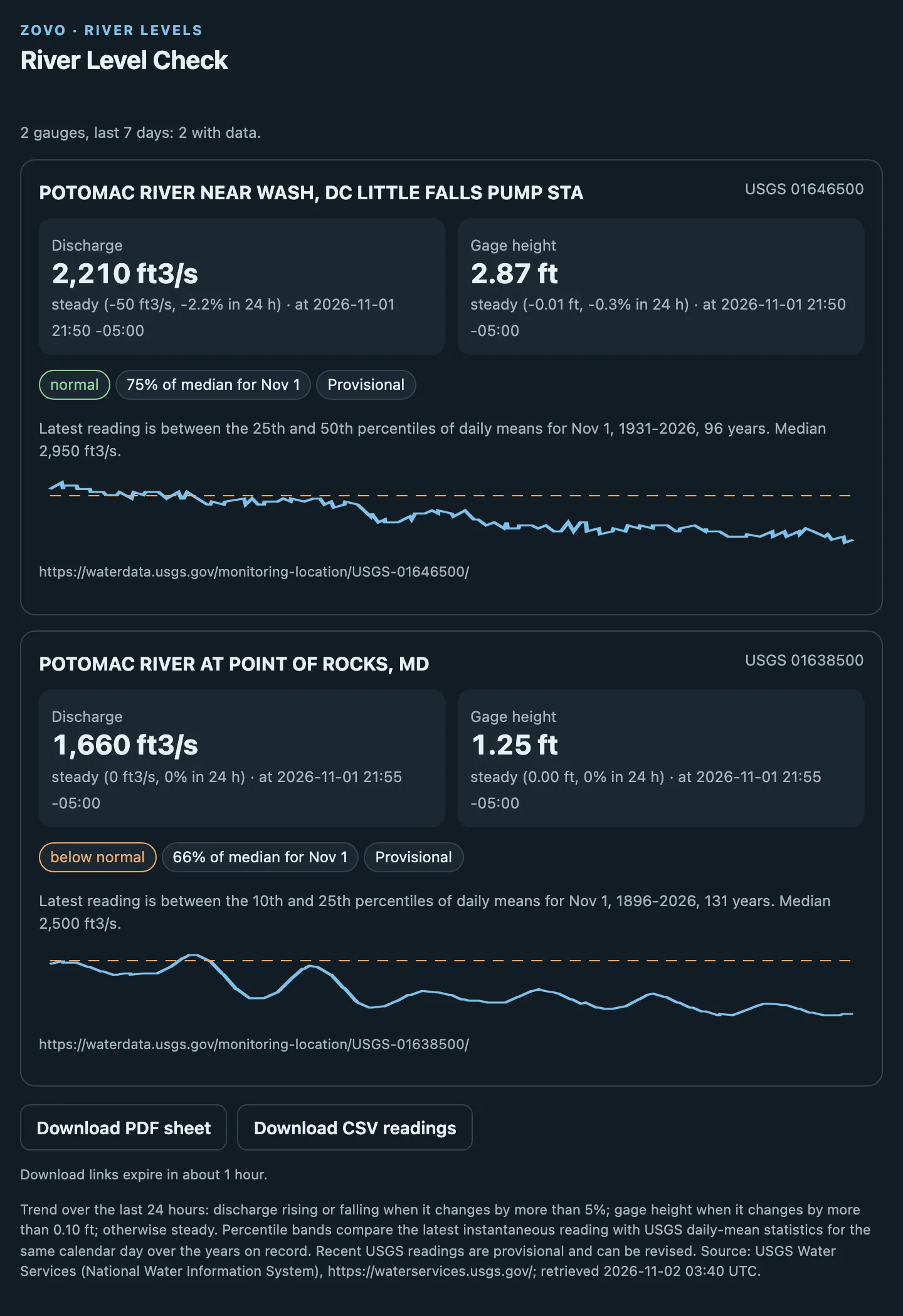
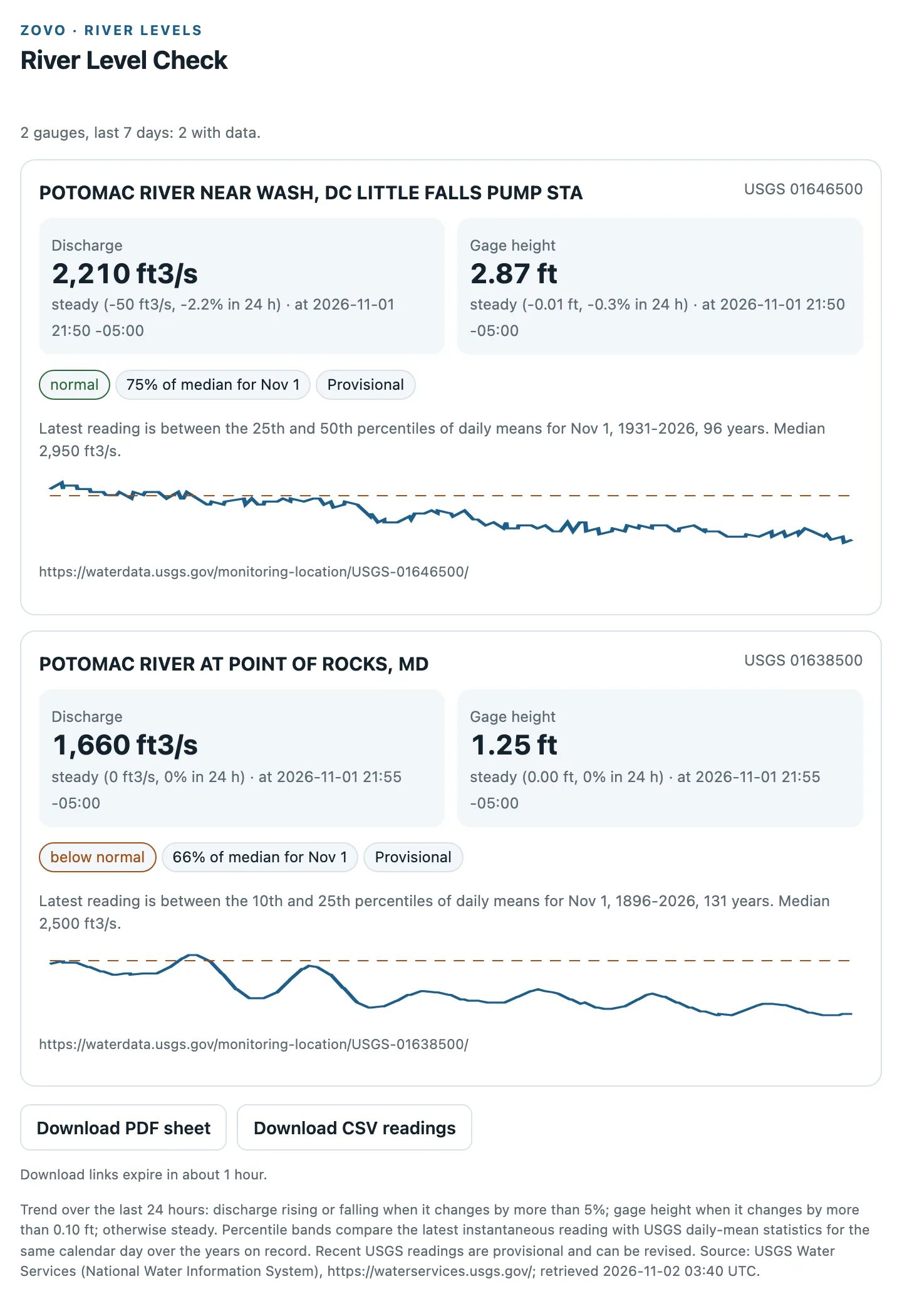
You askRiver levels for USGS gauges 01646500 and 01638500 over the last 7 days
RELEASE CHECK · 2 NOV 2026
A release review is not recorded yet.
This server is live and passed its build checks on 2 Nov 2026. An independent release review isn't recorded here yet. Inspect its limits and test a synthetic example before relying on it.
See the fleet snapshot and its limits ↗Custom connections require support in your AI app, plan, and workspace. Follow the host guide before you use the prompt.
A TASK TO TRY
Give the plugin a clear task.
River levels for USGS gauges 01646500 and 01638500 over the last 7 days
BEFORE YOU CONNECT
Check the limits.
Anonymous server discovery is checked. A current installation and widget test in both hosts is not recorded for this release.
- Recent USGS readings are provisional and can be revised.
- It is not a forecast or a flood warning. Follow National Weather Service warnings and local officials.
- Up to 10 US gauges per call.
- When USGS does not answer, the gauge is marked source unavailable and no values are shown.
WHAT THE SERVER EXPOSES
2 functions to request.
Names and descriptions below come from live MCP discovery. They describe the server; they are not a test of every function in ChatGPT or Claude.
Find river gauges
find_river_gaugesUse this when the user wants to find USGS river or stream gauges (site numbers) by US state and river name, or near a US city or town. Returns up to 25 active gauges with current data, with distance for city searches. Does not accept coordinates and does not return readings; use get_river_conditions for flow and gage height.
Get river conditions
get_river_conditionsUse this when the user wants current river flow (discharge) or gage height at USGS stream gauges, the 24-hour trend, how today compares with the same date in past years, or a printable condition sheet. Takes 1 to 10 USGS site numbers and 1 to 7 days; returns a PDF and a CSV of readings. Readings are provisional. Does not forecast and is not a flood warning; use find_river_gauges first when the site number is unknown.
Connect. Ask. Check.
- Use the setup guide for ChatGPT or Claude. Copy this plugin's endpoint.
- Connect the tool. Paste the sample prompt and supply the inputs it needs.
- Review the result before you rely on it. Check the source tool's limits and privacy terms.
ADAPT THIS TASK TO YOUR WORK
Need a different input or output?
Start a brief from Zovo River Level Check. Describe your inputs, the result you need, and the checks that define a useful result. Download it before you share it.
The brief runs in your browser. Custom projects need a separate scope and price agreement.
COLLECTIONS